7 Years
I had my Leatherman tool, on my belt, for seven years. My soon-to-be-PhD-advisor-at-the-time, Dr. Steven Siciliano, gave me a Leatherman Charge TTi - a top-of-the-line multitool - before my first field season with him and his research group in 2009. He gave it to me around March or April of that year, and I've worn it on my belt nearly every day since then.
That's around 2500 days of that lump of complex, hinged, bladed metal on my left hip. I've gone through three sheaths and I don't know how many subconscious hand-passes over my belt to make sure its still there.
Early this year I accidentally tried to take it through security at Pearson International Airport, on my way to visit Charlie in February. The security personnel were quite nice and polite about it, and let me mail it back to myself in Waterloo; it was waiting in my mailbox when I returned a week later.
At the end of my 6-week-long bookended-by-conferences early-summer-2016 fieldwork I sent it in to Leatherman's facilities in Burlington, Ontario, for warranty repairs. Before I flew from Calgary to Fredericton, I went to Canada Post and sent it to Ontario. Tonight, it has been returned to me.
Or rather, an updated substitute has been returned to me, and my Leatherman is no more. Because the Charge TTi has been replaced in the Leatherman Inc. lineup by the Charge Titanium, that is what I now have. This new Charge Titanium is a thing of beauty, a tool of vast utility that fits perfectly with the accessories (sheath, screwdriver bits) I was instructed not to send in. But it's not my Leatherman (yet).
The knife blade is flawless, not the chipped, scratched, and haphazardously-sharpened blade I used to cut ludicrously-fresh tomatoes and pears on the top of an Arctic mountain.
The saw blade is perfect, not the scratched, difficult-to-open tooth I used to cut branches and an uncountable number of zipties (using the sharp hook on its tip) on seven years of Arctic expeditions and Prairie Rivers canoe trips.
The file - both sides! - is clean to the point of optical illusion along its cross-hatched surface, and bears no trace of the steel soil-gas probes I filed and filed and polished and cursed before fitting their machinist-perfect but field-work-distorted hammer-cap on to drive into the rocky soil of the Arctic polar deserts.
The pliers are smooth and shiny, not the sticking, misaligned grip I pulled endless nails from endless boards with.
Even the scissors, tiny and sharp, are quite excellent, and not the cutters I pushed and squeezed through paper, string, cardboard, and plastic over the majority of a decade.
I'm going to enjoy and appreciate this tool over the next seven years - or more! - but I do feel like an old friend has been lost, and a concrete symbol of my PhD has disappeared.
Thank you, Leatherman, for making such fine tools. I hope my use of this new multitool lives up to the legacy of the previous one. And thank you, Dr. Siciliano, for sending me down this pathway seven years ago.
Showing posts with label Summer 2009. Show all posts
Showing posts with label Summer 2009. Show all posts
Friday, June 10, 2016
Saturday, January 23, 2010
Long Day Hike
090811
Two days ago, on August 9, several of us here at Alexandra Fjord hiked nearly the full north-south length of the ridge that borders the lowlands to the east. That was also the day the Canadian Coast Guard paid us a visit, but I did not talk about our long hike.
Katherine had work to do all day – she works very hard – so she could not join us, but the rest of us here left camp shortly before 10:00am. Myself, Ann, Sarah, Erin, and Knut quickly reached and crossed the larger, more distant river that flows near the eastern side of the valley and drains the Twin Glacier.
 The northern end of the ridge, viewed from near the southern edge of the Dome. The first leg of our route is shown in red.
The ascent up to the first saddle-ridge on the lowest hill was about half-covered in arctic blueberry bushes (Vaccinium uliginosum), with a mix of granite and dolomite on the steeper slopes. The rocks were similar for the ascent to the ridge-back, and the slope was never particularly steep and formed a series of shallowly-pitched and gently rounded benches.
Once up on the spine of the ridge, a broad and nearly flat boulder garden of granite, we could not see the valley nor the ocean to the east unless we wandered close to the edge. This terrain was quite different from anything I’ve walked any distance over before, a continuous expanse of large piled boulders, with occassional low dune-like ridges or bedrock outcrops.
 Part of the ridge-back, a field of boulders stretching to a near horizon. Patches were pink, others were grey, and every once in a while would be a large block of white quartz.
 On top of the tallest bedrock outcrop around, a few blocks of white quartz. Were they placed here by someone, or did they previously cap this block of granite, and crumbled under the onslaught of countless Arctic winters?
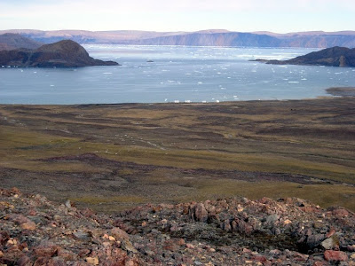
 The mouth of Alexandra Fjord where it opens to Buchanan bay.
The weather started quite good and got better during the day. It would have been difficult to choose better weather for our excursion. Lunch was had near the top of the ascent to the ridge, and we stopped occassionally while walking south for short breaks. It was during this stage that the differences in walking speeds in the group became apparent – Knut moved much faster than the rest of us, speeding ahead out of sight frequently, while Ann and Erin fell behind. I waffled between accompanying the slower walkers and and walking at my faster speed to explore. The speed of the group as whole, of course, was the speed of the slowest members, so moving very quickly was simply tiring.
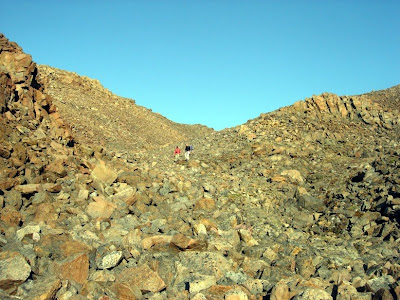
 Ann and Erin on the ridge-back.
 There were occassional patches of surprisingly lush vegetation scattered on the ridge-back, with incredibly bright-green willows and tall sedges growing among brilliant red, green, and black mosses.
We gauged our progress by our apparent position relative to the glaciers and ridges on the opposite side of the valley. After a few hours of fairly easy hiking, we realized we were well south of the toe of the Twin glacier, and that a proglacial lake described to us by other people and on a few maps must be nearby.
 Knut (I think) on a low wall of boulders on the ridge-back, with the Twin glacier’s parent icefield in the background.
 We decided the lake must be close when we encountered this road-like meadow running down to the west from the ridge-back.
 An undoctored photo I took of myself using the timer function on my camera. The rock I placed it on looked more level than it really was.
Knut and I pushed a little ways further to the south and west, and Sarah explored a bit to the west down the road-like meadow. After a bit of wandering, Knut declared he could see the described lake, and we congregated near the rocky point he had scrambled up.
 The upper reaches of the Twin glacier, showing the east lobe (nearer) and west lobe just above where they converge.
 What may or may not be the proglacial lake described to us previously. Certainly not reachable on this trip, it lies on the other side of a glacier flowing east to the sea (not visible in this picture) and is at least one kilometre from the furthest-south point we reached.
 My companions enjoying the spectacular views.
After fretting about the time for a bit (it was after 4:00pm by this point) we finally got moving again, descending and curving to the north below the road-like meadow. Our highest altitude achieved at our southern limit was about 750m. At around 450m there is a cluster of boulder piles that I marked in my GPS as “lumpy”.
 Just above the lumpy region.
The lumpy region narrowed into a series of canyons between towering piles of granite and dolomite. It was somewhat maze-like, but we managed to keep reasonably close together. This winding path descends steeper as we continued down and northward, approaching the flank of the Twin glacier below its convergence.
 Sarah and Knut admiring the view from atop a near-vertical rocky slope. The toe of the Twin glacier is imediately below and to their right. Not pictured: the very sketchy and difficult descent we made just below them.
The steepest descent was as we got quite near the flank of the glacier, and terrain that must have been covered by the glacier very recently. Based on comments made by people who have been at Alexandra fjord years ago, and by glaciologists, I would not be surprised to learn our route was glacier-covered only a few decades ago.
 Ann and Erin carefully descending the very steep and very loose boulder slope below the previous picture.
 Ann and Erin picking their way around a salt-encrusted bedrock outcrop that I had foolishly descended nearly straight down. The rocks are all very loose, such that actually secure foot- and handholds are nearly non-existent in this area. I came close to tumbling down a couple of times, and slid on my butt more than once to negotiate particular spots.
At the bottom of the really quite scary descent, close to the flank of the glacier, we entered a tiny canyon not unlike the tiny canyon Katherine and I found on the other side of the river below the Twin glacier. Sarah and Knut had descended first, and Knut had gone ahead to return to camp. The idea was that he would be able to return to camp in time to prevent too much worry on Katherine’s part, and to get dinner started.
 Ann and Erin in the tiny canyon.
 Ann and Erin at the mouth of the tiny canyon, just above where its tiny stream joins the main river draining the Twin glacier.
With Knut well on his way ahead of us, we rested for a time below the canyon, on a small meadow of moss and Cassiope heather beside the river. Everyone was tired, and we all needed a bit of a break after the sketchy steep descent we’d just gotten past.
After our rest, we proceeded north down the east side of the river, on a narrow strip of valley-bottom between the ridge and the river. We had left our chest waders near the river at its delta just above where it reaches the fjord.
 Walking down beside the river.
We reached camp just after 9:00pm, much later than had been planned. I was unaware, but plans had apparently been made to check-in by satellite telephone with Katherine at 6:00pm, and had included a belief that we’d be back by then in any case. Katherine had become quite concerned when we did not check in, and had not appeared some 2 hours after our supposed return time. Knut arrived and described our location and progress about 10 minutes before Katherine was thinking of heading out to look for us. Sorry, Katherine, that was a stupid mistake on our parts. While I can claim ignorance of the plans that led to this situation, I cannot claim a lack of responsibility, and I think I should have made my own plans regarding return and contact times. Sorry.
Overall, it was a spectacular day trip, and we covered around 15 kilometres of rough ground, with the gain and then loss of about 750m of altitude. The proglacial lake we saw may or may not have been the lake described to us previously, I’ve seen maps showing a lake near that position but I don’t know how much has changed with the retreating glaciers since those maps were made. If anyone else would like to try this hike, I recommend the following:
1. Make a better, firmer plan before departure. This is not extremely dangerous terrain, but medical or SAR assistance is normally very, very far away. We happened to have a Canadian Coast Guard icebreaker and its helicopter in our neighborhood, but even so this was by no means a totally safe trip.
2. Stick to the plan. One of the problems we had, fundamentally, was a lack of communication. Don’t say you “might” or “will try” to call at a certain time, say exactly what you will do and when, and make sure your safety person back at camp knows exactly what these details are.
3. Leave earlier. Much earlier. Without the distraction of the Coast Guard’s visit, we might have left at 9:00am. A 7:30 or 8:00 departure would have been far superior, and might have prevented some of the rushed feeling we had during the last couple of hours when we were at our most tired and moving slowly.
4. Bring spare camera memory and batteries. The views are truly amazing. You’ll take more pictures than you think.
Two days ago, on August 9, several of us here at Alexandra Fjord hiked nearly the full north-south length of the ridge that borders the lowlands to the east. That was also the day the Canadian Coast Guard paid us a visit, but I did not talk about our long hike.
Katherine had work to do all day – she works very hard – so she could not join us, but the rest of us here left camp shortly before 10:00am. Myself, Ann, Sarah, Erin, and Knut quickly reached and crossed the larger, more distant river that flows near the eastern side of the valley and drains the Twin Glacier.
 The northern end of the ridge, viewed from near the southern edge of the Dome. The first leg of our route is shown in red.
The ascent up to the first saddle-ridge on the lowest hill was about half-covered in arctic blueberry bushes (Vaccinium uliginosum), with a mix of granite and dolomite on the steeper slopes. The rocks were similar for the ascent to the ridge-back, and the slope was never particularly steep and formed a series of shallowly-pitched and gently rounded benches.
Once up on the spine of the ridge, a broad and nearly flat boulder garden of granite, we could not see the valley nor the ocean to the east unless we wandered close to the edge. This terrain was quite different from anything I’ve walked any distance over before, a continuous expanse of large piled boulders, with occassional low dune-like ridges or bedrock outcrops.
 Part of the ridge-back, a field of boulders stretching to a near horizon. Patches were pink, others were grey, and every once in a while would be a large block of white quartz.
 On top of the tallest bedrock outcrop around, a few blocks of white quartz. Were they placed here by someone, or did they previously cap this block of granite, and crumbled under the onslaught of countless Arctic winters?
 The mouth of Alexandra Fjord where it opens to Buchanan bay.
The weather started quite good and got better during the day. It would have been difficult to choose better weather for our excursion. Lunch was had near the top of the ascent to the ridge, and we stopped occassionally while walking south for short breaks. It was during this stage that the differences in walking speeds in the group became apparent – Knut moved much faster than the rest of us, speeding ahead out of sight frequently, while Ann and Erin fell behind. I waffled between accompanying the slower walkers and and walking at my faster speed to explore. The speed of the group as whole, of course, was the speed of the slowest members, so moving very quickly was simply tiring.
 Ann and Erin on the ridge-back.
 There were occassional patches of surprisingly lush vegetation scattered on the ridge-back, with incredibly bright-green willows and tall sedges growing among brilliant red, green, and black mosses.
We gauged our progress by our apparent position relative to the glaciers and ridges on the opposite side of the valley. After a few hours of fairly easy hiking, we realized we were well south of the toe of the Twin glacier, and that a proglacial lake described to us by other people and on a few maps must be nearby.
 Knut (I think) on a low wall of boulders on the ridge-back, with the Twin glacier’s parent icefield in the background.
 We decided the lake must be close when we encountered this road-like meadow running down to the west from the ridge-back.
 An undoctored photo I took of myself using the timer function on my camera. The rock I placed it on looked more level than it really was.
Knut and I pushed a little ways further to the south and west, and Sarah explored a bit to the west down the road-like meadow. After a bit of wandering, Knut declared he could see the described lake, and we congregated near the rocky point he had scrambled up.
 The upper reaches of the Twin glacier, showing the east lobe (nearer) and west lobe just above where they converge.
 What may or may not be the proglacial lake described to us previously. Certainly not reachable on this trip, it lies on the other side of a glacier flowing east to the sea (not visible in this picture) and is at least one kilometre from the furthest-south point we reached.
 My companions enjoying the spectacular views.
After fretting about the time for a bit (it was after 4:00pm by this point) we finally got moving again, descending and curving to the north below the road-like meadow. Our highest altitude achieved at our southern limit was about 750m. At around 450m there is a cluster of boulder piles that I marked in my GPS as “lumpy”.
 Just above the lumpy region.
The lumpy region narrowed into a series of canyons between towering piles of granite and dolomite. It was somewhat maze-like, but we managed to keep reasonably close together. This winding path descends steeper as we continued down and northward, approaching the flank of the Twin glacier below its convergence.
 Sarah and Knut admiring the view from atop a near-vertical rocky slope. The toe of the Twin glacier is imediately below and to their right. Not pictured: the very sketchy and difficult descent we made just below them.
The steepest descent was as we got quite near the flank of the glacier, and terrain that must have been covered by the glacier very recently. Based on comments made by people who have been at Alexandra fjord years ago, and by glaciologists, I would not be surprised to learn our route was glacier-covered only a few decades ago.
 Ann and Erin carefully descending the very steep and very loose boulder slope below the previous picture.
 Ann and Erin picking their way around a salt-encrusted bedrock outcrop that I had foolishly descended nearly straight down. The rocks are all very loose, such that actually secure foot- and handholds are nearly non-existent in this area. I came close to tumbling down a couple of times, and slid on my butt more than once to negotiate particular spots.
At the bottom of the really quite scary descent, close to the flank of the glacier, we entered a tiny canyon not unlike the tiny canyon Katherine and I found on the other side of the river below the Twin glacier. Sarah and Knut had descended first, and Knut had gone ahead to return to camp. The idea was that he would be able to return to camp in time to prevent too much worry on Katherine’s part, and to get dinner started.
 Ann and Erin in the tiny canyon.
 Ann and Erin at the mouth of the tiny canyon, just above where its tiny stream joins the main river draining the Twin glacier.
With Knut well on his way ahead of us, we rested for a time below the canyon, on a small meadow of moss and Cassiope heather beside the river. Everyone was tired, and we all needed a bit of a break after the sketchy steep descent we’d just gotten past.
After our rest, we proceeded north down the east side of the river, on a narrow strip of valley-bottom between the ridge and the river. We had left our chest waders near the river at its delta just above where it reaches the fjord.
 Walking down beside the river.
We reached camp just after 9:00pm, much later than had been planned. I was unaware, but plans had apparently been made to check-in by satellite telephone with Katherine at 6:00pm, and had included a belief that we’d be back by then in any case. Katherine had become quite concerned when we did not check in, and had not appeared some 2 hours after our supposed return time. Knut arrived and described our location and progress about 10 minutes before Katherine was thinking of heading out to look for us. Sorry, Katherine, that was a stupid mistake on our parts. While I can claim ignorance of the plans that led to this situation, I cannot claim a lack of responsibility, and I think I should have made my own plans regarding return and contact times. Sorry.
Overall, it was a spectacular day trip, and we covered around 15 kilometres of rough ground, with the gain and then loss of about 750m of altitude. The proglacial lake we saw may or may not have been the lake described to us previously, I’ve seen maps showing a lake near that position but I don’t know how much has changed with the retreating glaciers since those maps were made. If anyone else would like to try this hike, I recommend the following:
1. Make a better, firmer plan before departure. This is not extremely dangerous terrain, but medical or SAR assistance is normally very, very far away. We happened to have a Canadian Coast Guard icebreaker and its helicopter in our neighborhood, but even so this was by no means a totally safe trip.
2. Stick to the plan. One of the problems we had, fundamentally, was a lack of communication. Don’t say you “might” or “will try” to call at a certain time, say exactly what you will do and when, and make sure your safety person back at camp knows exactly what these details are.
3. Leave earlier. Much earlier. Without the distraction of the Coast Guard’s visit, we might have left at 9:00am. A 7:30 or 8:00 departure would have been far superior, and might have prevented some of the rushed feeling we had during the last couple of hours when we were at our most tired and moving slowly.
4. Bring spare camera memory and batteries. The views are truly amazing. You’ll take more pictures than you think.
A visit from the Canadian Coast Guard
Yesterday morning, before setting out on a long day-hike, we were unexpectedly visited by the Canadian Coast Guard, in the form of the helicopter from CCGS Henry Larson, an icebreaker currently conducting research on sea-ice and other marine matters in the High Arctic.
 The helicopter shortly after touchdown. These CCG helicopters seem more powerful than the Bell 204L operated by PCSP; at least its downdraft was more disruptive.
I had to help Katherine with her injections, so rather than stick around to chat with the people from the Coast Guard, I headed out. They were loading some equipment and packages into the helicopter, a pile of gear dropped off here at Alex Fjord a couple of weeks ago.
When I returned about half an hour later I expected the helicopter to be gone, and I was lamenting the poor timing that stole my opportunity to schmooze some government employees. Nearly everybody I’ve met likes to talk about their jobs, and life on an icebreaker sounds interesting.
However, while I’d seen the chopper leave, it had left behind 3 people, and would be returning soon. I grasped the situation before I talked to these people, so I opened the conversation with some sympathy for their position – I know how utterly boring it is to wait for a helicopter.
One of the people waiting was Michelle, a scientist studying multi-year sea-ice in the eastern Arctic. She was happy talk about her job, and give me names and contact information for people in the Coast Guard or Department of Fisheries and Oceans (DFO) who I could talk to about conducting research from such a ship. That would be highly cool. One positive little factoid she told me about was the busy season for scientific spaces on Canadian icebreakers. Not surprisingly, most scientists with projects that would benefit from the facilities of an icebreaker work in the summer; I do too. However, the ships generally return to their southern bases (St. John’s, in the case of CCGS Henry Larson) in late October, allowing several weeks of time in the High Arctic in the autumn. One avenue my upcoming PhD research might pursue is an examination of soil gas flux during freeze-up, which occurs between late August and the end of September at different latitudes in the Arctic. I can easily imagine a schedule of working full days or a few days in a row at a series of Arctic soil sites accessed by helicopter from an icebreaker. Perhaps a few weeks cruising down through the Archipelago? This is very appealing to me, not least because such ships have a number of other valuable resources besides the chopper – things like showers, lab space, a reliable electricity supply, and other scientists to discuss projects and experiments with.
After my wonderful conversation with Michelle, the helicopter returned to retrieve her and her shipmates. The ship itself was lurking out in the mouth of Buchanan bay, hidden from our view by the rocky headland to our east.
CCG Helicopter take off
My companions, except Katherine, and I quickly set out on our big day-hike shortly after Michelle’s departure. We crossed both rivers to the east of camp, and climbed up to the top of the lower hill that forms part of the barrier of the valley to the east. From the top we could see the ship maneuvering near the mouth of Buchanan bay.
 Erin modelling some men’s-size-12 chest waders before crossing the larger and more distant river.
 The view from part-way up, looking back towards camp.
 The view to the east from the saddle at the top of the first slope. Greenland is barely visible as a shadow on the horizon when viewed through binoculars.
 CCGS Henry Larson steaming into Buchanan bay. Skraeling island and Little Skraeling island are visible at the bottom of the frame.
 A cropped photo taken through my binoculars. I was told by one of Michelle’s shipmates that CCGS Henry Larson is 337 feet long. I think the bridge is 4 stories above the forward deck, to give an idea of the size of this vessel.
 CCGS Henry Larson steaming into Alexandra Fjord, viewed from the hilltop at about 250m altitude. I think they rammed through that isolated iceberg just because they could. I’d asked about the amount of ice breaking the icebreaker had been doing, and was told they had been crunching through quite a bit of ice already. The sound reached us clearly at our vantage point.
 A view of the ship from a few hours later, after we’d ascended partway up the north face of the eastern ridge. They apparently decided to park in the fjord for a while.
We continued our hike and lost sight of the ship, and did not hear the helicopter flying around. When Michelle and her shipmates were picked up I briefly talked with the helicopter pilot, who asked me (jokingly, I thought) if there was anything we needed that he could bring us. I said something about not having had a banana in a while (this is true: the last banana I saw came from the BAS visit), but otherwise thought nothing of it – we really are in need of nothing at base camp.
When we returned from our long day hike, Katherine related a story to us. She’d seen the ship come into the fjord, of course, and watched the helicopter buzz around and a zodiac zip up and down the fjord. I think one of the scientists on board is studying tides, and there’s a buoy of some kind with a data logger, or something. Anyways, she was working inside the lab and heard the helicopter land, and waited for the engine to shut down, signalling the arrival of more visitors. The (very loud) engine kept running, so she went outside to investigate. The crew of the chopper waved her closer – they had landed very close to the buildings anyways – then pointed to some boxes they’d dropped off from the chopper, a gift for us.
The gift was about 50 pounds of various fresh fruits and vegetables. I was kind of expecting a handful of bananas, but we got much, much more than that.
 One half-emptied box of food from the Canadian Coast Guard.
 Another box of fruit.
They gave us bananas, apples, pears, plums, nectarines, raspberries, blackberries, honeydew melons, oranges, kiwis, tomatoes, and cucumbers, enough to feed the 6 of us on a strict frugivore diet for days, plus a litre of coffee cream, 2 big cardboard flats of single-serve yogurt, and some cheese. All of this was delivered by helicopter in a single-purpose trip from the ship.
Thank you!
Busy at Alexandra Fjord
090810
The past two days have been pretty exciting, so rather than trying to write one giant post, I’ll split up the stories across 3 posts. Today has been my first chance to sit down and write about these things, mainly due to a lack of time, but the on-going electricity situation has also contributed.
It’s quite an odd feeling to be frequently concerned about one’s electricity supply – we take it so much for granted most of the time. Here at Alexandra Fjord, there are two ways to get electricity for one’s devices; typically we use the power we have to charge batteries for various electronics like laptop computers and digital cameras. First, we have a few generators. These are used to power scientific instruments, such as the FTIR at various field sites, and Katherine’s Gas Chromatograph (GC) in the lab at base camp. When a generator is running, other devices can be plugged in – under most circumstances we’d be hard-pressed to push these generators beyond their idle power output. Second, there is a photovoltaic (PV) system – solar power – connected to the household wiring system of the base camp buildings. The PV system is complicated and idiosyncratic, and is based entirely on the mind of Dr. Greg Henry: he designed it, bought and shipped the parts, assembled it, and knows its limitations. The rest of us just sort of guess. For example, right now I’m running my laptop computer off of this system, and I’m actually trying to drain the batteries a little bit because we think the batteries may be overcharged right now. I know very little about such things, but at least this way I don’t have to wait until Katherine wants to run her GC before I can recharge my camera’s battery.
 Speaking of my camera, here’s a picture of CCGS Henry Larson just offshore of our base camp, taken yesterday.
Tuesday, November 17, 2009
I'm on TV!
As I described previously, in late July of this year we were visited by a crew from Global Television at Alexandra Fjord. They spent about 2 days filming us and the suroundings, and they said this footage would be edited down to make one of a number of roughly 60-second vignettes to be broadcast before the evening news.
Well, I guess they kept their word. Here's the bit I'm in.
Full disclosure: I'm realistically faking it in the parts I'm in. While those are reasonably accurate portrayals by me of my day-to-day activities at Alexandra Fjord, I didn't actually write anything in my notebook there, and I didn't actually collect any data from that chamber at that time.
And Anne would probably kill me if I mentioned that she was none too pleased about being asked to look at a specimen of Eriophorum with a magnifying glass, nor would she be happy if I reiterated her (much repeated) point that no self-respecting botanist would need to use such a glass to examine any plant of that genus.
Tuesday, October 06, 2009
Solo Walkabout
090810
Two days ago, on August 8, I had a whole day in front of me and nothing pressing in need of doing. I’d just finished helping Katherine with her morning 15N injections, and at about 9:30am I decided I’d like to do a little exploring in the Alexandra Fjord area. It was a clear day, without too much wind, so I packed a lunch and some cold-weather gear (just in case) and set off to see the lower slopes of the Dome and the west side of the valley.
 My goal for the day’s adventure, a traverse at near-constant altitude across the east slope of the Dome, from south to north. My route is indicated by the red line.
Rather than cross any rivers by myself, a dangerous and uncomfortable task, I planned to walk diagonally south and west across the valley away from base camp until reaching the north-flowing small river that supplies are our drinking water. This would be the same river that Katherine and I crossed on our previous excursion. Then I would follow the river upstream as it curves to the south and east, ascend the Dome to the first major bench, and traverse along the Dome at this height until I felt like coming back down and returning to camp.
 The north half of the drinking-water river, viewed from a spot not far from where Katherine and I crossed it nearly 2 weeks ago.
 There has been little erosion in the 12 days since I last passed this way. The bootprint on the left is from that previous trip, on the right freshly-formed.
 The cottongrass (Eriophorum sp.) was in full display.
 I nearly stumbled into this tiny side-channel of the river.
Moving southwest not far from the river, I crossed a broad, nearly-level plain littered with large glacial erratics – boulders deposited by a retreating glacier. There are lots and lots of such erratics all over northern North America, remnants of the last great ice sheets some 15000 years ago. One such large erratic is the basis for the name of a brewery in Calgary, Alberta. The difference here on Ellesmere Island is that the glacier that left these erratics behind is still very much in place, and has a name, in this case the Twin glacier.
 An antler was resting on this multi-tonne behemoth of an erratic, and the white was visible from much further away than the distinctive shape.
 The view from atop the erratic in the previous photo, looking north back towards base camp and the fjord.
 The terrain forced me closer to the river, and for a while I was following my companions footprints, retrograde. Here is a footprint made by one of my companions when they descended from Katherine and my camp on the Dome on July 9, a month ago.
The north half of the river emerges from a canyon known as “Helm’s Deep”, descending swiftly through a channel of boulders and steep walls. I had no desire to chance the river’s current, but I wanted to see into the canyon, so I climbed a short distance alongside the rushing river before I decided "enough of this!" and scrambled up the north wall of the canyon. That scramble was probably the most tricky thing I did that day, a careful half-crawl up a steep and crumbly slope of granite boulders, soft gravel, and loose sandy soil.
 The view to the south from the rocky point above the north wall of the Helm’s Deep canyon.
 Another view from the same spot, looking northeast.
My altitude where I paused to take the above photos and drink my coffee was 186 metres, according to my GPS. This number would appear again and again on my GPS screen as I traversed the bench of mixed granite and dolomite that forms this part of the Dome. I was trying to stay at roughly the same altitude, periodically turning on and checking my GPS, and while I strayed a bit, up to about 200m, down to about 170, for some reason by far the most common reading was exactly 186m.
 The view of base camp from the bench. The “Willow” and “Wet Sedge Meadow” OTCs are visible below and to the left of base camp.
 “Cassiope” OTCs.
 “Dryas” OTCs.
 “Vaccinium / Fert” OTCs.
The terrain of the bench was a mix of polar desert and wetter patches of tundra. The differences between the two ecosystems are very apparent when they are so closely juxtaposed.
 Polar desert.
 Tundra, at least by my estimation.
I continued along the bench until I got hungry, then stopped for lunch on a prominent boulder or protrusion of bedrock. I like having a spectacular view during my meals.
 The view from near my lunch spot towards base camp. The light-coloured pile of rubble on the left partially covers the granite block I sat upon to eat.
I continued around to the north slope of the Dome, where the structure gradually changes from a dolomite-dominated series of benches to a granite-dominated series of vertically-running channels and shallow, steeply-pitched canyons. This granite structure is much more difficult to traverse laterally, besides which I thought I should be heading back towards camp because I was scheduled to make dinner that evening.
 The view north from the north slope of the Dome. Several of the icebergs had large melt-pools on them.
 I was struck (not literally) by this precariously-balanced boulder on my way down the north slope.
 The boulders here were very loose and unstable, so I wasn’t able to get as close to this boulder as I’d like.
 I did get close enough to include my hand for scale.
Below the north slope of the Dome there is a narrow strip of wet and boggy tundra, covered with a mix of sedges and black mosses. This is apparently the home of a couple of pairs of parasitic jaegers (Stercorarius parasiticus), and I met one. I spent some time verbally berating it, thinking it was a juvenile with low muscular endurance, because it repeatedly flew only a few metres, then landed, then flapped around and took off for another short flight. On later reflection, it’s more likely this was an adult faking injury to lure me away from a nest. This late in the season it seems improbable that there are any non-flying juveniles or eggs around, but this behaviour is probably an instinctive response to a potential predator.
 The fake-injured jaeger I followed and verbally abused for a bit.
I walked along the shoreline to the west, up towards the top of the fjord, and freaked myself out a little bit with some bearanoia: I was carrying no deterrents, not even “bear banger” firecrackers, and I knew I was in primo polar bear habitat. Fortunately, I encountered no bears.
It was very quiet, and there was little wind, perfect conditions for sound to travel far. I could hear a marine mammal periodically surfacing, so I walked down a short way and saw a pair of walruses (Odobenus rosmarus) diving and surfacing.
 A cropped photo taken through my binoculars of the pair of walruses. They sit low in the water even when resting on the surface, so the distinctive tusks were only rarely visible at all, and then only the uppermost parts.
On my way back to base camp, I must have passed right through two jaeger territories, as I was dive-bombed repeatedly by 4 different birds, including the fake-injured dark-coloured individual I’d previously yelled at. Turnabout is fair play, I suppose.
VIDEO: Jaeger attack 1
VIDEO: Jaeger attack 2
Their attacks were quite spectacular, and I did get a bit of an adrenaline charge as these quite large birds (larger than a crow, similar to an average sea gull) wheeled in the sun and feinted towards my head. My camera was rapidly running out of battery power, so I tried to quickly escape the jaegers, but their territories are rather large and I was attacked off-and-on for about 10 minutes.
I got back to camp by about 3:00pm, more than enough time to get started on dinner. Overall, a very satisfying jaunt around the western side of the Alexandra Fjord lowlands.
Two days ago, on August 8, I had a whole day in front of me and nothing pressing in need of doing. I’d just finished helping Katherine with her morning 15N injections, and at about 9:30am I decided I’d like to do a little exploring in the Alexandra Fjord area. It was a clear day, without too much wind, so I packed a lunch and some cold-weather gear (just in case) and set off to see the lower slopes of the Dome and the west side of the valley.
 My goal for the day’s adventure, a traverse at near-constant altitude across the east slope of the Dome, from south to north. My route is indicated by the red line.
Rather than cross any rivers by myself, a dangerous and uncomfortable task, I planned to walk diagonally south and west across the valley away from base camp until reaching the north-flowing small river that supplies are our drinking water. This would be the same river that Katherine and I crossed on our previous excursion. Then I would follow the river upstream as it curves to the south and east, ascend the Dome to the first major bench, and traverse along the Dome at this height until I felt like coming back down and returning to camp.
 The north half of the drinking-water river, viewed from a spot not far from where Katherine and I crossed it nearly 2 weeks ago.
 There has been little erosion in the 12 days since I last passed this way. The bootprint on the left is from that previous trip, on the right freshly-formed.
 The cottongrass (Eriophorum sp.) was in full display.
 I nearly stumbled into this tiny side-channel of the river.
Moving southwest not far from the river, I crossed a broad, nearly-level plain littered with large glacial erratics – boulders deposited by a retreating glacier. There are lots and lots of such erratics all over northern North America, remnants of the last great ice sheets some 15000 years ago. One such large erratic is the basis for the name of a brewery in Calgary, Alberta. The difference here on Ellesmere Island is that the glacier that left these erratics behind is still very much in place, and has a name, in this case the Twin glacier.
 An antler was resting on this multi-tonne behemoth of an erratic, and the white was visible from much further away than the distinctive shape.
 The view from atop the erratic in the previous photo, looking north back towards base camp and the fjord.
 The terrain forced me closer to the river, and for a while I was following my companions footprints, retrograde. Here is a footprint made by one of my companions when they descended from Katherine and my camp on the Dome on July 9, a month ago.
The north half of the river emerges from a canyon known as “Helm’s Deep”, descending swiftly through a channel of boulders and steep walls. I had no desire to chance the river’s current, but I wanted to see into the canyon, so I climbed a short distance alongside the rushing river before I decided "enough of this!" and scrambled up the north wall of the canyon. That scramble was probably the most tricky thing I did that day, a careful half-crawl up a steep and crumbly slope of granite boulders, soft gravel, and loose sandy soil.
 The view to the south from the rocky point above the north wall of the Helm’s Deep canyon.
 Another view from the same spot, looking northeast.
My altitude where I paused to take the above photos and drink my coffee was 186 metres, according to my GPS. This number would appear again and again on my GPS screen as I traversed the bench of mixed granite and dolomite that forms this part of the Dome. I was trying to stay at roughly the same altitude, periodically turning on and checking my GPS, and while I strayed a bit, up to about 200m, down to about 170, for some reason by far the most common reading was exactly 186m.
 The view of base camp from the bench. The “Willow” and “Wet Sedge Meadow” OTCs are visible below and to the left of base camp.
 “Cassiope” OTCs.
 “Dryas” OTCs.
 “Vaccinium / Fert” OTCs.
The terrain of the bench was a mix of polar desert and wetter patches of tundra. The differences between the two ecosystems are very apparent when they are so closely juxtaposed.
 Polar desert.
 Tundra, at least by my estimation.
I continued along the bench until I got hungry, then stopped for lunch on a prominent boulder or protrusion of bedrock. I like having a spectacular view during my meals.
 The view from near my lunch spot towards base camp. The light-coloured pile of rubble on the left partially covers the granite block I sat upon to eat.
 I continued around to the north slope of the Dome, where the structure gradually changes from a dolomite-dominated series of benches to a granite-dominated series of vertically-running channels and shallow, steeply-pitched canyons. This granite structure is much more difficult to traverse laterally, besides which I thought I should be heading back towards camp because I was scheduled to make dinner that evening.
 The view north from the north slope of the Dome. Several of the icebergs had large melt-pools on them.
 I was struck (not literally) by this precariously-balanced boulder on my way down the north slope.
 The boulders here were very loose and unstable, so I wasn’t able to get as close to this boulder as I’d like.
 I did get close enough to include my hand for scale.
Below the north slope of the Dome there is a narrow strip of wet and boggy tundra, covered with a mix of sedges and black mosses. This is apparently the home of a couple of pairs of parasitic jaegers (Stercorarius parasiticus), and I met one. I spent some time verbally berating it, thinking it was a juvenile with low muscular endurance, because it repeatedly flew only a few metres, then landed, then flapped around and took off for another short flight. On later reflection, it’s more likely this was an adult faking injury to lure me away from a nest. This late in the season it seems improbable that there are any non-flying juveniles or eggs around, but this behaviour is probably an instinctive response to a potential predator.
 The fake-injured jaeger I followed and verbally abused for a bit.
I walked along the shoreline to the west, up towards the top of the fjord, and freaked myself out a little bit with some bearanoia: I was carrying no deterrents, not even “bear banger” firecrackers, and I knew I was in primo polar bear habitat. Fortunately, I encountered no bears.
It was very quiet, and there was little wind, perfect conditions for sound to travel far. I could hear a marine mammal periodically surfacing, so I walked down a short way and saw a pair of walruses (Odobenus rosmarus) diving and surfacing.
 A cropped photo taken through my binoculars of the pair of walruses. They sit low in the water even when resting on the surface, so the distinctive tusks were only rarely visible at all, and then only the uppermost parts.
On my way back to base camp, I must have passed right through two jaeger territories, as I was dive-bombed repeatedly by 4 different birds, including the fake-injured dark-coloured individual I’d previously yelled at. Turnabout is fair play, I suppose.
VIDEO: Jaeger attack 1
VIDEO: Jaeger attack 2
Their attacks were quite spectacular, and I did get a bit of an adrenaline charge as these quite large birds (larger than a crow, similar to an average sea gull) wheeled in the sun and feinted towards my head. My camera was rapidly running out of battery power, so I tried to quickly escape the jaegers, but their territories are rather large and I was attacked off-and-on for about 10 minutes.
I got back to camp by about 3:00pm, more than enough time to get started on dinner. Overall, a very satisfying jaunt around the western side of the Alexandra Fjord lowlands.
Subscribe to:
Posts (Atom)

