Summer field work in Canada south of the Arctic Circle often gets started in May, or late April if conditions allow. There are four sites in northern/central Alberta where I'd like to do some science, and two conferences to bookend this early-summer setup season, so I created a plan back in February / March to spend around one week at each site, covering the last week of April through to late May.
The first site to visit was Fort McMurray; we're continuing work with Suncor on their wetland reclaimation / restoration project, and we have a handful of "reference" sites in the area. Sarah, a master's student in our lab, was planning to spend the entire summer working at Fort McMurray on these sites, and because her work is largely focused on hydrology (especially the transport of dissolved materials through the study systems), she wanted to get some instruments into place as early as possible. In an ideal year, that would have included snowmelt, but given how weird 2016 has been pretty much everywhere, we had to satisfy ourselves with the last week of April.
I flew from Munich, Germany (my weekend in Munich will be the subject of another post, sometime) to Calgary on Monday, April 25, stayed with my parents one night - a too-short visit by far! - then picked up my rental car Tuesday morning. I drove up to Fort McMurray, an entirely uneventful 7-hour drive up the middle of the province.
We had our Kickoff meeting - a general overview of the project, with an emphasis on safety with our contacts / immediate supervisors at Suncor - on Wednesday morning, then Sarah and I got to work installing her runoff collectors and carrying out other beginning-of-field-season type work. I've had to explain these tasks in varying levels of detail to a range of other people - safety folks at Suncor, passers-by, other researchers, etc. - and to be honest, the details have kind of blurred together at this point. Digging and playing with soil, for the most part.
Suncor has tight rules regarding photographs at their property, and while I do have a valid camera pass, I have to submit any photos I plan to share with the world (websites, scientific conferences, etc.) to a manager at that company, and at the moment I think they have higher priorities to worry about. I have lots more to say about this issue, but not right now. So, no pictures of Sarah's experimental apparatus, or anything else at Suncor.
We can only work at Suncor on weekends if we really need to, and we didn't, so we had a chance to visit the reference sites on Saturday and Sunday. My side project, a look at the effects on greenhouse gas exchange (especially methane) of the cutlines so abundant in the Canadian boreal forest, needed to get started. Sarah and I went to Saline on Saturday, expecting a modest day - maybe 6 hours of work - and a need to work fairly hard given the still-frozen soil in many places and the long walk in to Saline. Saline is, as the name suggests, a fen (a wetland with a direct connection to groundwater, contra a bog, without such a connection) with high levels of dissolved ions in the local water supply. The vegetation community is dominated by sedges and reeds, with very few mosses able to tolerate the high salinity.
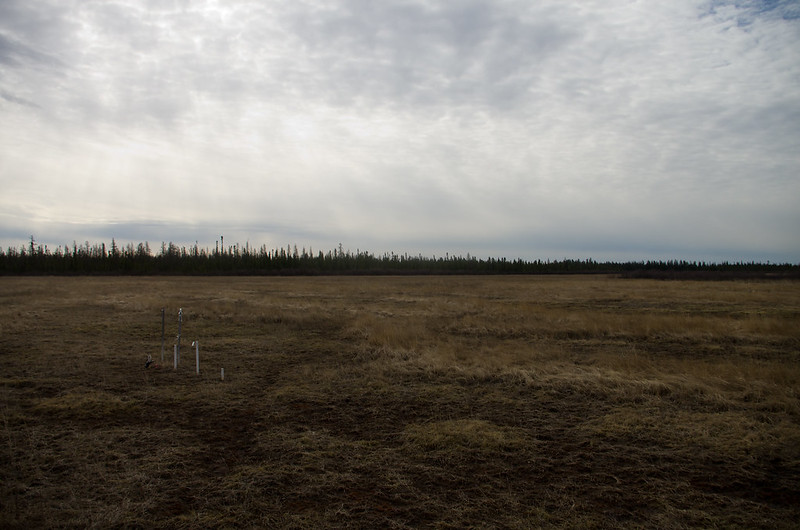
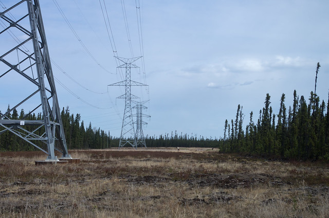
The Saline Fen. The pipes sticking up in the front-left are a nest of piezometers, used to measure water flows through this fen.
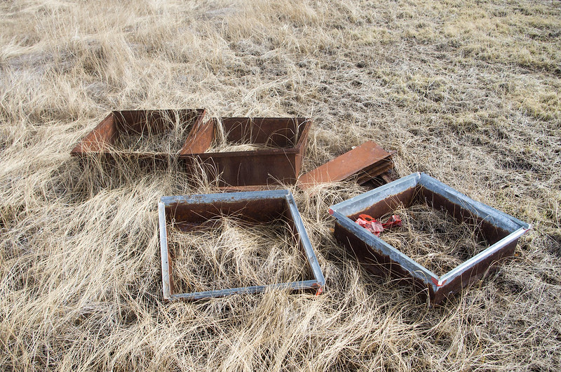
We use 60x60cm collars to isolate patches of ground and measure greenhouse gas exchange. Ours are constructed of steel, and rust rapidly in the salty peat of the Saline Fen.
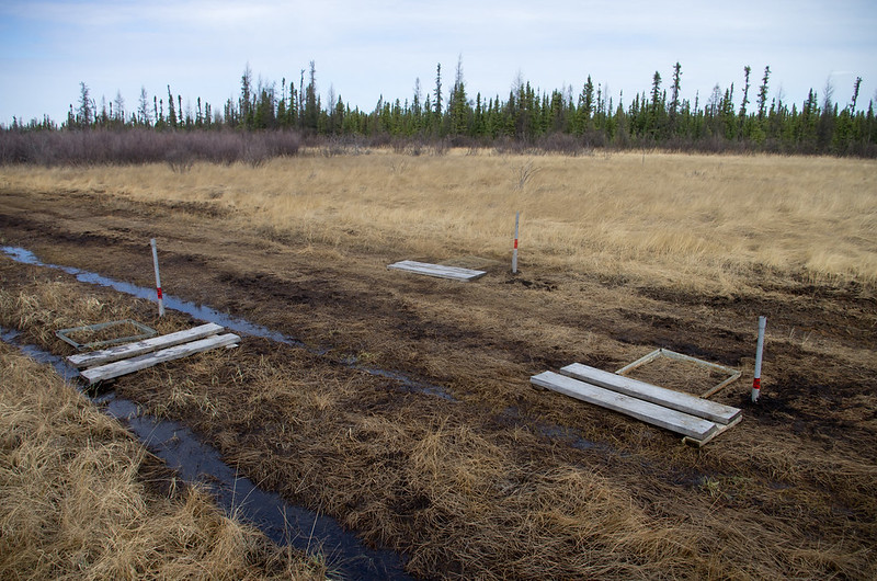
My new collars (actually, just relocated old collars that were not too rusty), on the cutline that cuts right through the Saline Fen. I'm not sure why this cutline was constructed; possibilities include to provide a winter road or temporary access to areas beyond the fen, a seismic survey looking for buried deposits (in this part of the world, oil), or some other reason.
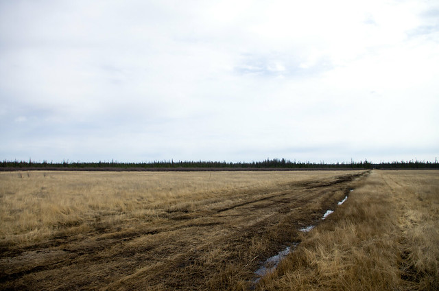
The cutline, continuing on to parts unknown.
On our way out - surprisingly early, we were back at the truck by 11:30 - we spotted a couple of caribou (Rangifer tarandus).
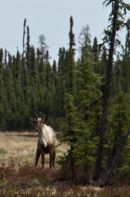
One seemed a little curious about us.
We returned to the house in Fort McMurray rented by the University of Waterloo, and had a few small tasks to complete mostly concerned with getting ready for Sunday, with a visit to Poplar, a tree-covered bog.
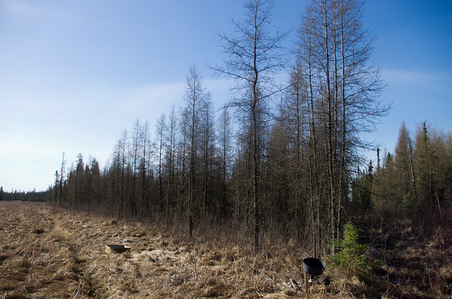
Poplar Bog. Both the "Large" and "Small" cutlines are visible here, along with the patch of "undisturbed" bog between them where I placed my reference collars.
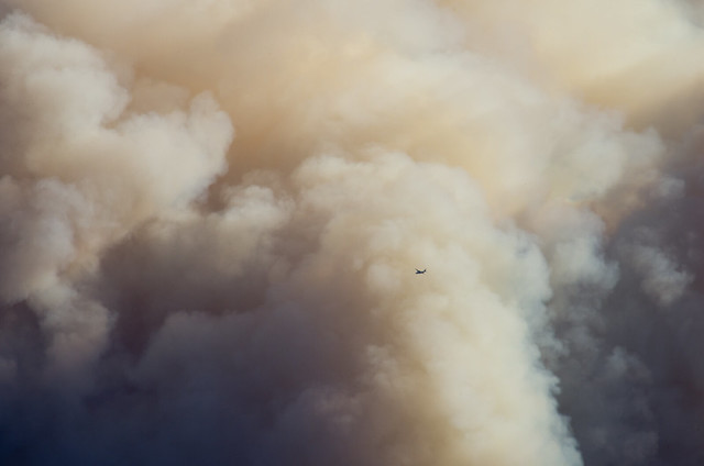
Despite a greater number of collars to install and more difficult soil conditions - ice was close to the surface at Poplar, and abundant tree roots made cutting into the peat especially challenging - we were again finished before lunchtime. My plan was to drive to Peace River, a road distance of nearly 700 km, on Monday so I could attend a required safety training course in Peace River on Tuesday morning. Sunday afternoon was thus spent in quiet relaxation. Later in the afternoon we noticed the smoke plumes to the south and to the north, indicating wildfires. Wildfires are not particularly rare in the boreal forest, and given the hot, dry conditions the area had experienced all April, such a fire in the forests near Fort McMurray was not surprising.
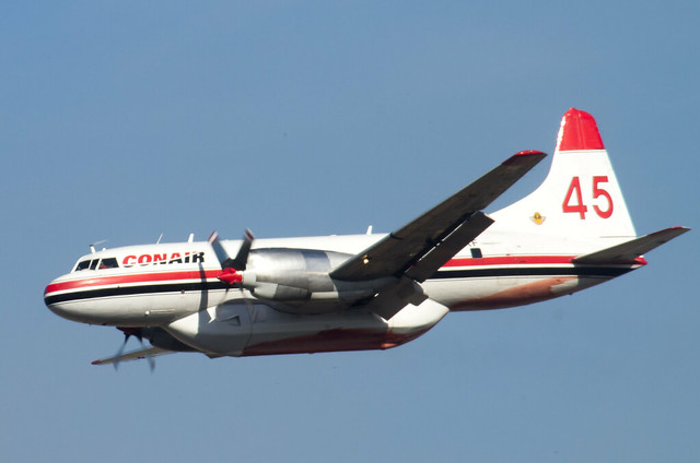
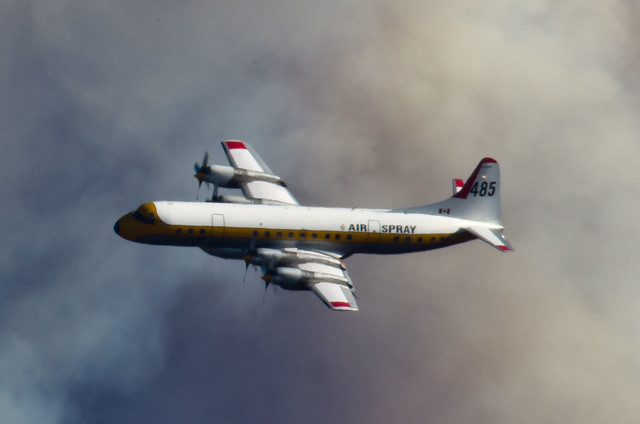
We treated the circling firefighting aircraft - we saw at least three water-bombers plus at least two helicopters carrying buckets and one "birddog" control-and-direction airplane - as a pleasant and interesting diversion on a sunny Sunday afternoon. I was a pretty enthusiastic airplane nerd when I was around 10 years old, and I snapped a few pictures.
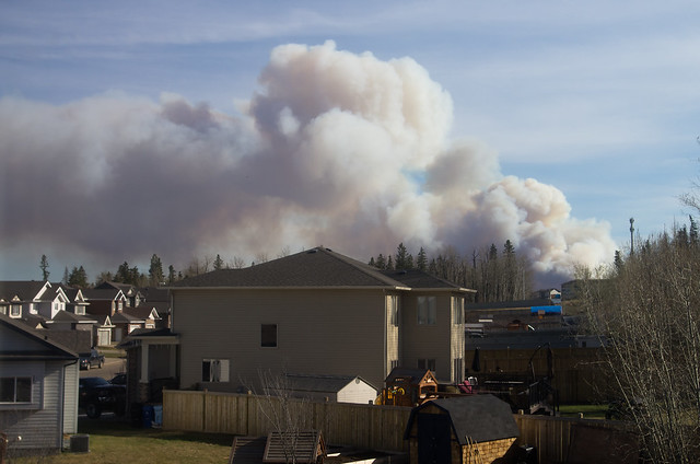
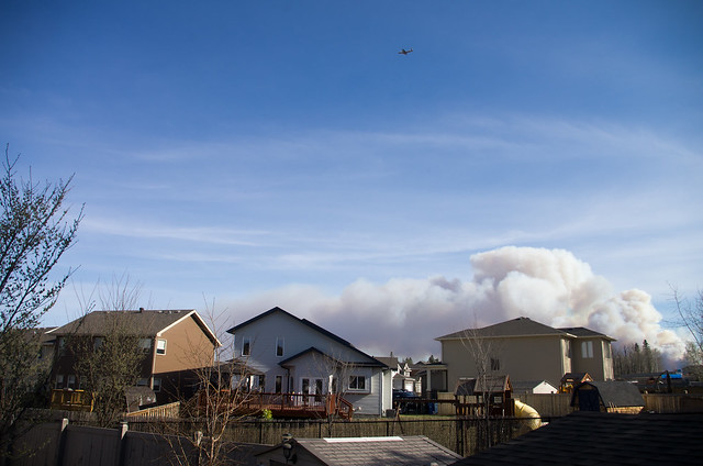
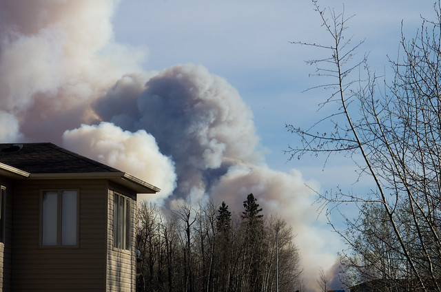
Suburbia-and-smoke shots
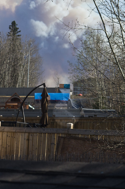
It's hard to see, so I've highlighted the water stream, but a neighbour a few houses down was watering their lawn. I took this picture thinking it made an amusing contrast, but in hindsight it takes on more of a futile-gesture feeling.
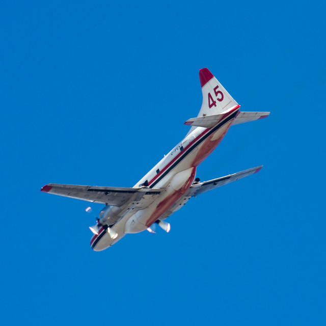
I snapped this shot off at an awkward angle, but it shows the red stain from the firefighting foam this airplane has been dispensing. I saw none of the famous Canadair scooper-type waterbombers, and these 'planes need to return to an airport after dropping their loads. The advantage of the foam over water is greater wetability - water isn't actually that wet, especially when splashed onto burning trees. And, I'm not certain that a scooper would be able to operate effectively around Fort McMurray - the Athabasca river has very few straight parts, I don't know how deep it is, and there are few large lakes in the area.
Sunday night was quiet - I don't think waterbombers usually operate at night - and Monday morning included a heavy haze of smoke over the city. I dawdled my morning, sticking around long enough to wash and dry the sheets from my bed, and triple-check I wasn't leaving anything behind.
Conditions cleared up completely once I was about 15km south of town, and my drive down the infamous Highway 63 was about as calm and uneventful as is possible. Highway 63 is infamous because of the high death rate during the peak boom years, about 4-5 years ago. The news across Canada would periodically cover the more spectacular crashes, most of which were generated by young men with large incomes and powerful cars beyond their abilities to properly control driving at ridiculously high speeds and making dangerous passes on the two-lane undivided highway. Last summer I saw intense construction activity all along Highway 63 from its junction with 55, about 250 km south of Fort McMurray; this year, they appear to have completely twinned the highway except for one short section that feels like a normal construction zone. I stopped for fuel in Wandering River, and continued on my way.
The rest of that drive is more interesting, but I'll save that for another post. It wasn't until Tuesday evening that I realized the wildfires I had seen near Fort McMurray were actually forming an existential threat to the entire city. Sunday afternoon we'd joked about the smoke, asking each other how far away that fire might be, and I remember saying something like "It must be pretty far away, they'd pull out all the stops if it gets too close to the city. There's no way they'd let Fort McMurray burn." The amazing damage to the city and the total evacuation puts the lie to my confidence in the unlimited abilities of northern Alberta firefighters. This fire - apparently now named "The Beast" - is beyond any normal human efforts, and I can only salute the crews working to minimize the damage from my safe vantage point.
Peace River is living up to its name, in stark contrast to the catastrophe I accidentally avoided.


No comments:
Post a Comment