We made very good time, despite the moderately-heavy backpacks we were each carrying, and by about 8:45 we crossed out of Truelove’s polar oasis habitats and into the polar desert habitats of the greater part of Devon Island.
 A satellite image from Google showing the Truelove lowlands (on the left, dark green) and the terrain adjacent to the East and South. The Truelove river is the black line meandering across the bottom of the image. The large light-coloured blob is the Dolomite Dome, which appears as two separate hills when viewed from ground level. The scale bar is 2 km long (1 mile marked below).
 I took this photo at about 8:30am. The spine of dark granite in the middle distance marks the edge of the Truelove lowlands. Behind it and to the right the Truelove river, the Southern border of the lowlands, flows towards Jones sound which separates Devon from Ellesmere.
 Among the granite boulders on the upper parts of the granite spine we encountered an Arctic Hare (Lepus arcticus). It seemed surprisingly unafraid of us, and Eric was able to approach to within about 5 metres to photograph it. It didn’t run away from us, even after our photography when we rather noisily continued on our way.
 Looking back towards the West, from just above the Truelove river. The terrain we were walking through at this point was very clearly the result of glacial and river erosion of the surrounding granite-and-dolomite rocks. There were no trails, but much of our walking was through what were obviously old riverbeds. I suspect this river has changed its flow rate drastically in the past, drying to a mere trickle at some times and expanding to a raging flood at others. Currently, the river flows swiftly, and appears to be about 2 metres deep in the center on average.
 We found a musk-ox (Ovibos moschatus) skull perched upon a rock. Somebody else has been here before us, but Arctic conditions mean I have no idea how long ago this animal died, or when the skull was moved. The rest of the skeleton was scattered over a few square metres, about 20 metres away.
 An Iceland Poppy (Papaver nudicaule), about 20 cm tall. Most of the glacial / river valley was just barren rock with a little encrusting lichen for colour. However, sheltered pockets contained agreeable microclimates, and sported some surprisingly healthy-looking plants, like this one here. We saw many poppies, some as large as this one, others much smaller and growing in more exposed areas.
 Another warm microclimate, this time adjacent to a tiny stream, about 10cm at widest. I took this picture because of the “stoplight” appearance of these mosses and lichens.
 I named this pond “Dolomite Pond”, because it is floored by light-coloured dolomite. I sampled here, on the far shore and at the outflow (to the right). There were some interesting worms (Enchytraeidae) and insect larvae (Chironomidae and Tipulidae) among the decaying moss around the rocks and mud. The surrounding meadow was also interesting, and included a number of plants that were uncommon or absent on the lowlands. Eric found Arctic Blueberries (Vaccinium uliginosum) just above the pond, which he had not found in Truelove but had seen on Ellesmere Island at Alexandra Fjord.
 Looking to the West, from above and East of Dolomite Pond. We stopped for lunch after climbing up a rough granite boulder-field above Dolomite Pond. We had intended to reach an apparently-smooth bench of dolomite above us, that looked like easier walking than the tumbled granite we were in. Once again, the Arctic fooled us, and it was much further and harder to get to the dolomite bench than either of us expected. As can be seen here, the terrain on the bench is not particularly smooth or flat, and there are many boulders scattered about. In addition, dolomite erodes to form razor-sharp, jagged edges, such that the bit of scrambling we periodically engaged in put us at risk of sliced skin on our fingers and hands.
 We walked along the dolomite bench for a bit, then decided we needed to set a turn-around point since it was becoming clear we were unlikely to actually reach the base of the glacier. At this point, we had just rounded the major Northward-turning bend of our path, and we could not see anything glacier-like (our search image for this task was basically anything enormous, distant, and icy). So we went up, intending to cut a diagonal path to the West and North over the top of the dolomite dome. The going was tough.
It took about an hour for us to power our way up the steep side of the dolomite dome. Dolomite is rapidly becoming my least-favourite natural material, because of how it erodes and weathers. At smaller scales, I’ve already mentioned the razor-sharp edges on the boulders and rocks. At larger scales, dolomite appears to slump into a series of benches. Each bench appears to be the summit when viewed from below, until one stands upon the lip of the bench and sees the next rise immediately in front. I think we crossed 10 or 12 such bench-edges, to the point that I did not really believe it when we finally did achieve the summit.
 Our reward on the top of the dolomite dome was a view of the Devon Ice Cap, the ice field that is the source of several glaciers, most notably (from our point of view) the Belcher Glacier that flows North. I really felt like I was looking back in time 100 000 years, to the ice of the Pleistocene, the “ice age”. Views like this must have been common throughout Northern North America, Europe, and Asia as recently as 15 000 years ago.
 This pyramidal boulder seems to represent the true summit of the dolomite dome. We didn’t actually ascend the final gentle slope to it, partly because we didn’t want to risk yet another disappointment generated by a bench of stone. The terrain here is mostly smallish pieces of dolomite, smashed and packed together into a solid mass.
 Eric and I were happily striding along over the easy terrain of the top of the dome when we nearly stumbled upon this ravine. We pondered for a minute or two, then decided to descend the ravine and follow it out to its mouth to the South, rather than trying to go around its upper end to the North or re-ascend a dolomite slope on the far side. Partly this decision was based on our uncertainty regarding the terrain ahead: a descent and climb would be tiring, and there could easily be another ravine hiding just over the near horizon. The walls of this ravine are steeper than this picture makes them look, they’re probably pitched at close to 35 degrees. The dolomite pieces of the walls of the ravine are distinctly geometric shapes - I stepped on numerous pieces that were straight-edged squares, long rectangles, or triangles.
 The floor of the ravine, more jumbled dolomite, but at least here, like the summit, it’s reasonably flat. A stream emerged from underground a little way down the ravine, and Eric and I were grateful for the chance to refill our water containers. I also found some insect larvae here, probably Simuliidae (blackfly) larvae. There’s almost nothing at all in the water or growing on the rocks, so I don’t know what those maggots are eating.
 This spectacular waterfall was partially visible from several places along our ascent this morning, but we were never in a position with a clear view of the entirety of it. A river flows from the ice cap above and to the south through black granite before pouring off the cliff edge in a fantastic spray. The sound of this waterfall was audible everywhere in the valley and on the dolomite. The patch of brownish-green to the left of the falls (not really visible in this picture, sorry) is a steep shelf of granite covered by what appears to be a thick layer of moss, supported by the continuous spray from the waterfall. The main fall strikes a large boulder or shelf (that we could not directly see) about 2/3 of the way down, creating a back-spray that soaks the mossy shelf. Basically, it’s always raining there in summer. I suspect that micro-ecosystem will perish when erosion inevitably changes the shape of that strike-plate, ending the permanent rain.
 Another view of the waterfall, with the Truelove river below.
 Yet another view of the waterfall, taken from where Eric and I rested for a few minutes and voraciously consumed beef jerky. We came out of the ravine well above our path this morning. We suspect the ravine terminates near the river in the form of a largish ditch that Eric and I briefly noted on our way across. The upper areas of the valley on the North side are covered in quite lush meadows that are generally very wet. There are few decent places to sit down, but we did OK.
 Our approach to the Truelove lowlands, higher and further North than our departure route. The dark line of granite in the middle distance on the left is the edge of the ridge we crossed this morning. Here, water seems to have pushed the edge of our bench down, disrupting the meadow in a sloping boulder pile. Nearly all of the lowlands are visible from the spot just ahead, with only the part closest to the dolomite dome on the right hidden from view.
After admiring the view, and eating yet more beef jerky, we chose a careful path down through a boulder field of mixed granite and dolomite, with the sound of water trickling through concealed passages beneath us. By this point, we were both pretty tired and well knew it, so we went more slowly than had been usual up to this point, because a twisted ankle or sprained wrist at this point would be really, really annoying.
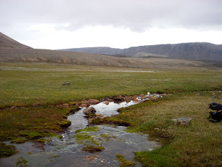 Looking back at our route, from the lowlands. We descended from the bench near the darker granite on the right of this image. We refilled our water bottles again at this stream, in which we saw a few small fish. Arctic Char (Salvelinus alpinus) are the only freshwater fish in the High Arctic; presumably the tiny fish we saw were juveniles.
 One of the many lakes of the Truelove lowlands, which we skirted around on our way back to camp.
I think the people in camp were a little surprised to see Eric and I back before dinner time. We dropped our packs, took off our boots, and generally just sat around for about half an hour after our arrival at about 5:15. The maps we have of the Truelove area suggest that Eric and I covered nearly 30 kilometres and 400 metres of altitude change today.
Tomorrow there is a possibility that I will fly back to Resolute with Steve, depending on the weather and the availability of aircraft. This mostly depends on the requirements of a research group working on the Belcher Glacier, who have two camps and need to shift some equipment and personnel around, and on how hard Steve lobbies to get out. My own desires to clean my laundry rank poorly in the list of motivators of flight schedules.


5 comments:
Nice hike, you are really making me want to get to the high Arctic, I passed up a trip to go 4 years ago and have been kicking myself ever since, this didn't help.
Ben
Hi Ben,
Yes, the High Arctic is pretty spectacular. Sorry to hear you've got regrets in that direction. I'm sure other opportunities will come up. I know there are some guided operations for tourists that go to that neighbourhood, but I have no idea how much something like that costs.
Yes well we all have regrets, and as far as I'm concerened this is a minor one, I will go at some point so no worries. As to the cost, you don't want to know :(
Great on the ground, relatively recent account, about a unique enviroment. Is their a name for the falls you photographed?
Those falls have no name I know of, though I will now take the opportunity to name them "Oasis Falls" after the Truelove Lowland Polar Oasis towards which they tumble.
They almost certainly have another name already, so whatever.
Post a Comment