Start: 308908 km
End: 309154 km
Driven: 246 km
 Saskatoon is a city at an arbitrary location. There is no confluence of rivers, shore of a Great Lake, ocean coast, valley opening up from the hills, or any other obvious natural terrain feature to justify a trading post developing into a town and then into a city. What is here is the railroad. Saskatoon houses some large rail yards, and the city more-or-less owes its existence to the subtle grades across the landscape that railroad planners, nearly alone among people, pay attention to. So I decided to explore a bit along those lines.
A major rail route out of Saskatoon runs to the east by southeast; part of this track runs near my friends' house on the southern edge of town. It parallels Highway 16 for hundreds of kilometres, though the more-recent highway tends to stay a dozen or so kilometres from the tracks. There are rural, secondary and tertiary highways that stay closer to the tracks for portions of its length; the easiest access for me to one of these smaller roads was through the town of Bradwell.
 Bradwell isn't big, but it's big enough to warrant a sign on the northern route of the TransCanada Highway for access. And it even has a few services, apparently.
 It was a beautiful, clear sunny day; of course this means I spent some time driving straight into the low-hanging sun. My first glimpse of the railroad is here, in the form of a level crossing just ahead.
Rather than follow the road into the tiny town of Bradwell, I crossed the tracks then looped back along a dirt road that runs parallel to the tracks for a few hundred metres before re-crossing the tracks and running between the town's grain elevator and the railroad. Presumably this road exists because of that grain elevator. Unfortunately I didn't think to snap a picture as I cruised slowly under the loading arm hanging out from the elevator.
 FLAT! I know I say this too much, but... look at it!
The main road that had been pavement going through Bradwell became dirt/gravel soon after, but at this time of year and in these conditions, a gravel road is actually easier to drive on than pavement. With little snow, frequent strong winds to blow snow away, and low temperatures, the gravel is frozen in place, and smooth ice cannot form. On pavement, snow compressed by passing vehicles doesn't blow away, and often forms quite slick ice patches.
 A little ways beyond Bradwell, this slight bit of terrain broke the cue-ball surface of this part of the planet.
 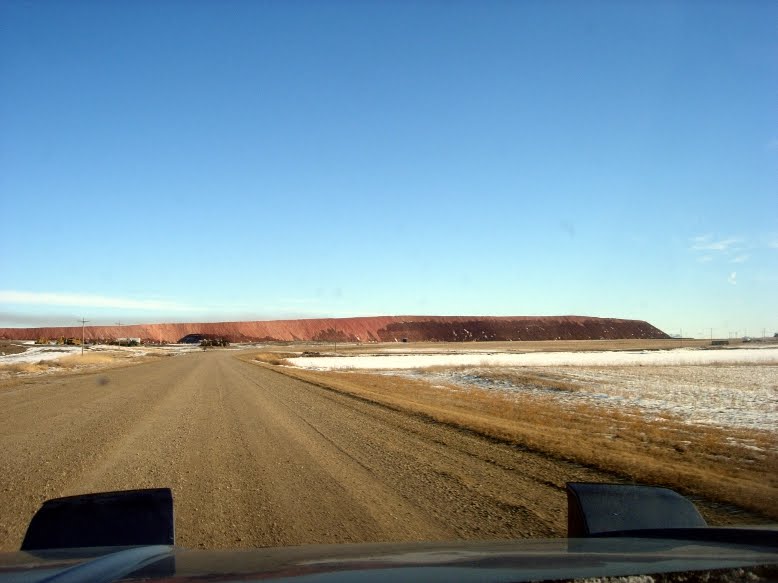 A pile of soil, that's been there long enough the road I was on dodges to the right to avoid it. What caused this?
 This facility was hiding around the corner of the pile.
 This is the Allan Potash Mine. According to the website of the Potash Corporation of Saskatchewan, this one mine is a globally-significant contributor to world fertilizer production.
 The importance of this facility to world trade is shown here by the large number of bulk-carrier rail cars on a long spur apparently built specifically to carry the mine's output.
I have heard it said that the toxic algal blooms that frequently cause trouble on the Gulf of Mexico coast are the fault of Saskatchewan, because this province exports so much potash fertilizer to the vast agricultural fields of the American mid-west. Runoff from these farms fills the Mississippi river with huge concentrations of industrial-agricultural chemicals, which end up in the shallow near-shore waters of the northern Gulf of Mexico and cause the blooms. Saskatchewan's potash mines are not a key contributor to this: potash is K2CO3, and marine algae are limited neither by potassium nor carbonate supply (ocean water contains plenty of both); the blooms are triggered by the relaxation of the limits on their supply of phosphorus and nitrogen.
Beyond the mine lies the town of Allan, which I skirted around on Provincial Highway 763. This road passes through or near to a number of towns with unusual names. After Allan, I passed Zelma, Young, and Xena, before turning north at the town of Watrous. I was driving down the alphabetic line and didn't even know it! Look closely at a map of Saskatchewan, and you'll see the names of towns starting with sequential letters of the alphabet. From Bradwell to Watrous I crossed the end-points of two adjacent lines.
 Near the north side of the town of Watrous is the Manitou and District Regional Park. Like the other Regional parks I've visited since I bought this car, this park was closed. Unlike those others, the gate was locked. Oh well, I probably would have gotten stuck in the snow had I been able to venture inside.
Continuing north on provincial highway 365, I reached the tiny resort town of Manitou Beach. Saskatchewan contains a large number of lakes sitting in isolated watersheds - liquid water has no way to reach the sea if it lands inside these basins. The resulting lakes and wetlands inside these watersheds vary in their chemical and biological characteristics - some are essentially freshwater, but many are saline to different degrees, and some contain Artemia spp. brine shrimp populations. Little Manitou lake is saltier than the ocean, and the resort here grew up from legends of medical benefits associated with bathing in or drinking the waters. There's very little such activity in winter, though.
 Approaching Little Manitou lake.
 I stopped in the small parking lot next to a lake-shore restaurant. I was hoping to see some indication of the possibility of driving onto the lake's surface, but I saw no boat ramps and no tire tracks on the surface - just some cross-country ski tracks. It took me a couple of minutes to clue in to the fact that no normal person drives onto a saline lake, because there's no point - there are no fish in this lake, which also eliminates the biggest reason to install a boat ramp.
 Driving along the shore of Little Manitou lake.
 Highway 365 crosses Little Manitou lake via a causeway near the eastern end of the lake. The field to my right is probably swampy wetland rather than either proper lake or regular prairie. The road is very close to the water level, I guess there's little variation in the height of the lake.
 The terrain just north of Little Manitou lake is more parkland than open plains, with large patches of trees separating gently rolling fields.
Eventually I met up with Highway 16, and decided to follow it back home to Saskatoon. It's a pretty boring road.
 Hahaha weeeee!!! Or something.
 The Allan potash mine is visible from a long way away; the smoke it exhausts is visible from much further. According to Google Earth, the closest Highway 16 gets to the mine is about 6.5km; I think I took this picture from close to that point.


2 comments:
So Have a lot of time at work today. The Alphebet line continues into AB, pretty neat really. Also the "Smoke" from the potash mine is mostly water vapor.
Ben
Yeah, I thought the exhaust was probably mostly water. It's white and fluffy for the most part, and given the air temperatures that day (around -20) I'd expect even a little bit of airborne moisture would look like a cloud.
Post a Comment